


![Average Land Surface Temperature [Day]](/images/datasets/132x66/MOD_LSTD_CLIM_M.jpg)
![Average Land Surface Temperature [Night]](/images/datasets/132x66/MOD_LSTN_CLIM_M.jpg)


![Land Surface Temperature Anomaly [Day]](/images/datasets/132x66/MOD_LSTAD_M.jpg)
![Land Surface Temperature Anomaly [Night]](/images/datasets/132x66/MOD_LSTAN_M.jpg)
![Land Surface Temperature [Day]](/images/datasets/132x66/MOD_LSTD_M.jpg)
![Land Surface Temperature [Night]](/images/datasets/132x66/MOD_LSTN_M.jpg)


NEO News
Washington Post Snow Cover Visualization
March 6th, 2013 by Kevin Ward
The Washington Post featured imagery from NEO as part of their visualization illustrating changes in snow cover since 2010.
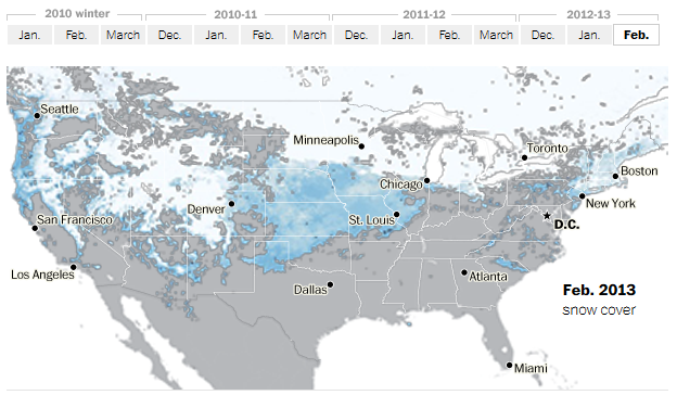
View Timelapse: A look at where snow has fallen at the Washington Post.
Exploring the Role of Snow Cover in Shaping Climate with NEO
November 12th, 2010 by Kevin Ward
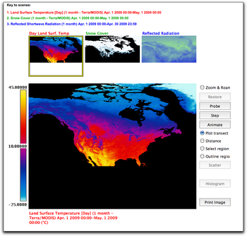
In this chapter from the Earth Exploration Toolbook, you can investigate satellite images displaying land surface temperature, snow cover, and reflected shortwave radiation data from NEO.
Download, explore, and animate these images using ImageJ, a public domain image analysis program from the National Institutes of Health (NIH). Then use the web-based analysis tools built into NEO to observe, graph, and analyze the relationship between the three variables.
- Browse by Topic
- Analysis
- NEO in the Media
- New Datasets
- Services
- Uncategorized
- Browse by Date
- May 2023
- April 2021
- February 2021
- December 2020
- November 2020
- October 2020
- September 2020
- June 2019
- March 2019
- April 2015
- April 2014
- December 2013
- November 2013
- August 2013
- March 2013
- June 2012
- June 2011
- April 2011
- November 2010
- August 2010
- February 2009
- May 2008
- April 2007