


![Average Land Surface Temperature [Day]](/images/datasets/132x66/MOD_LSTD_CLIM_M.jpg)
![Average Land Surface Temperature [Night]](/images/datasets/132x66/MOD_LSTN_CLIM_M.jpg)


![Land Surface Temperature Anomaly [Day]](/images/datasets/132x66/MOD_LSTAD_M.jpg)
![Land Surface Temperature Anomaly [Night]](/images/datasets/132x66/MOD_LSTAN_M.jpg)
![Land Surface Temperature [Day]](/images/datasets/132x66/MOD_LSTD_M.jpg)
![Land Surface Temperature [Night]](/images/datasets/132x66/MOD_LSTN_M.jpg)


Leaf Area Index (1 month - Terra/MODIS)
About this dataset
Have you ever flown in a plane over a forest, or seen a picture of a forest canopy taken from above? If so, you probably noticed the forest canopy was colored shades of dark green. The trees' and plants' leaves give the forest its lush green appearance. The more leaves there are in a forested area, the greener the tree canopy. Have you ever wondered how many leaves there are in a forest? Today, scientists use NASA satellites to map leaf area index — images processed to show how much of an area is covered by leaves. For example, a leaf area index of one means the area is entirely covered by one layer of leaves. Knowing the total area covered by leaves helps scientists monitor how much water, carbon, and energy the trees and plants are exchanging with the air above and the ground below.
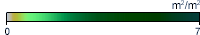
What do the colors mean?
The colors in this palette range from tan, showing little or no leaf cover, to light green, indicating the area is entirely covered by one layer of leaves, to dark green showing thick forest canopies, where seven or more layers of leaves cover an area. Black means no data.
Get Data
1. Visit the LP DAAC site
2. Select Access Data and download from one of the listed data access tools. You will need to create/ sign in to your Earthdata account.
Related Websites
Further Reading
MODIS Measures Total US Leaf Area
A New Way to View Vegetation
Seasonal Swings in Amazon Leaf Area
Leaf Area Index, South America
ATBD (Algorithm Theoretical Basis Document)
Credits
Imagery produced by the NASA Earth Observations team based on data provided by the MODIS Land Science Team.
Federal Geographic Data Committee Geospatial Metadata
View the FGDC Metatdata for Leaf Area Index (1 month - Terra/MODIS)