


![Average Land Surface Temperature [Day]](/images/datasets/132x66/MOD_LSTD_CLIM_M.jpg)
![Average Land Surface Temperature [Night]](/images/datasets/132x66/MOD_LSTN_CLIM_M.jpg)


![Land Surface Temperature Anomaly [Day]](/images/datasets/132x66/MOD_LSTAD_M.jpg)
![Land Surface Temperature Anomaly [Night]](/images/datasets/132x66/MOD_LSTAN_M.jpg)
![Land Surface Temperature [Day]](/images/datasets/132x66/MOD_LSTD_M.jpg)
![Land Surface Temperature [Night]](/images/datasets/132x66/MOD_LSTN_M.jpg)


Sea Surface Salinity (1 month, 2011-15)
About this dataset
These maps show the saltiness, also known as “salinity,” of the ocean surface. The ocean's salinity is key to studying the water cycle and ocean circulation, both of which are important to Earth's climate.
Throughout Earth's history, the weathering of rocks has delivered minerals, including salt, into the ocean. Over decades, this amount of salt in ocean basins has been relatively stable. The water cycle operates on much faster time scales, however, causing changes in salinity patterns. For example, freshwater enters the ocean from rivers, melting ice, rain, and snow. These processes tend to make the ocean less salty. On the other hand, processes that cause freshwater to exit the ocean—such as evaporation and formation of sea ice—make the ocean saltier.
Differences in salinity play a major role in moving seawater around the globe. Below the wind-blown ocean surface, salinity and temperature drive circulation by controlling the “density” (mass per unit volume) of seawater. The weight of dissolved salt increases water's density and when salinities are equal, colder water is denser than warmer water. In addition to moving salt and water, density-driven circulation is crucial to moving heat around our planet. The movement of heat by our ocean—for example, from the equator to the poles—is crucial to keeping Earth's climate “just right.”
These maps are made from satellite observations which cover the globe every week. The black areas show where data were not available, usually close to the coasts where strong signals from the land can interfere with accurate measurements.
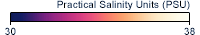
What do the colors mean?
The colors of these data indicate the areas of low (dark purple) to high (light yellow) salinity in practical salinity units (psu). The Practical Salinity Scale (of which psu is a component) is used to describe the concentration of dissolved salts in water and defines salinity in terms of a conductivity ratio, so it is dimensionless. Black areas show were data were not available.
Get Data
1. Create/ Sign in to your Earthdata account
2. Download the data you need here: PO.DAAC Drive
Notes
The Aquarius mission ended on June 8, 2015 when an essential part of the power and attitude control system for the SAC-D spacecraft, which carries the Aquarius instrument, stopped operating. read more
Related Websites
Further Reading
A Measure of Salt
Measuring Salinity from Space
Satellites and Salinity
The Cottage Industry Chasing Ocean Surface Salinity
ATBD (Algorithm Theoretical Basis Document)
Credits
Imagery produced by the NASA Earth Observations team based on data provided by the NASA JPL Physical Oceanography Distributed Active Archive Center (PO.DAAC).
Federal Geographic Data Committee Geospatial Metadata
View the FGDC Metatdata for Sea Surface Salinity (1 month, 2011-15)