


![Average Land Surface Temperature [Day]](/images/datasets/132x66/MOD_LSTD_CLIM_M.jpg)
![Average Land Surface Temperature [Night]](/images/datasets/132x66/MOD_LSTN_CLIM_M.jpg)


![Land Surface Temperature Anomaly [Day]](/images/datasets/132x66/MOD_LSTAD_M.jpg)
![Land Surface Temperature Anomaly [Night]](/images/datasets/132x66/MOD_LSTAN_M.jpg)
![Land Surface Temperature [Day]](/images/datasets/132x66/MOD_LSTD_M.jpg)
![Land Surface Temperature [Night]](/images/datasets/132x66/MOD_LSTN_M.jpg)


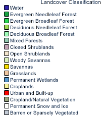
Land Cover Classification (1 year)
About this dataset
Maps help us understand where things are. Scientists use satellites to make maps of many different things on Earth to help them understand our world and how our world is changing. Judging by what the land surface looks like, scientists organized Earth into 17 different categories. Some examples of different types of land surface are cities, farm lands, forests, deserts, and so forth. Using satellite observations, scientists mapped where on Earth each of these 17 land surface categories can be found. The different colors on this map show the locations of each type of land surface. Scientists are monitoring how these land cover types change over time.
Get Data
1. Visit LP DAAC
2. Select Access Data
3. Choose one of the data access tools listed and search for the dataset name (MCD12C1)
Related Websites
Further Reading
MODIS Measures Total US Leaf Area
New Land Cover Classification Maps
Long Term Drought Parches Chile
ATBD (Algorithm Theoretical Basis Document)
Credits
Imagery produced by the NASA Earth Observations team using data provided by the MODIS Land Team and the Land Processes Distributed Active Archive Center.
Federal Geographic Data Committee Geospatial Metadata
View the FGDC Metatdata for Land Cover Classification (1 year)