


![Average Land Surface Temperature [Day]](/images/datasets/132x66/MOD_LSTD_CLIM_M.jpg)
![Average Land Surface Temperature [Night]](/images/datasets/132x66/MOD_LSTN_CLIM_M.jpg)


![Land Surface Temperature Anomaly [Day]](/images/datasets/132x66/MOD_LSTAD_M.jpg)
![Land Surface Temperature Anomaly [Night]](/images/datasets/132x66/MOD_LSTAN_M.jpg)
![Land Surface Temperature [Day]](/images/datasets/132x66/MOD_LSTD_M.jpg)
![Land Surface Temperature [Night]](/images/datasets/132x66/MOD_LSTN_M.jpg)


Sea Ice Concentration and Snow Extent, Global (1 day - SSM/I / DMSP)
About this dataset
The colors on this collection of daily global maps show where the land and ocean was covered by snow (gray and white) and ice (blue). If you browse through these maps you will notice that snow and ice cover Earth's polar regions with bright white caps all year round. But at lower latitudes the extent of snow and sea ice changes as the seasons change. Scientists measure how much of our world is covered by snow and ice to help them better understand and predict changes in Earth's weather and climate.
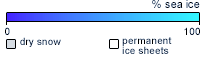
What do the colors mean?
The dark- to light-blue colors indicate the percentage of sea ice cover for the given time period. Light gray areas show dry snow extent over land. White areas show the permanent ice sheets on Greenland and Antarctica. Black indicates where there is no data.
Get Data
1. Visit the NSIDC site
2. Make sure you create/ sign in to an Earthdata account
3. Choose the parameters you need and download from the column on the right for HDF files. Or, you can select Other Access Options and download from one of the tools/ sites listed there.
Notes
Issues related to data production resulted in no data being ingested for this dataset from May 8, 2009 to January 3, 2010.
Related Websites
Special Sensor Microwave/Imager (SSM/I)
National Snow & Ice Data Center
Near Real-Time SSM/I EASE-Grid Daily Global Ice Concentration and Snow Extent
Further Reading
Polar Bears Struggle as Sea Ice Declines
Sea Ice Below Normal Despite a Seasonal Bump
Arctic Lows
Arctic Sea Ice Reaches Second Lowest Extent
Credits
Images by National Snow and Ice Data Center (NSIDC) in Boulder, Colorado, using satellite passive microwave data from the Special Sensor Microwave/Imager (SSM/I).
Federal Geographic Data Committee Geospatial Metadata
View the FGDC Metatdata for Sea Ice Concentration and Snow Extent, Global (1 day - SSM/I / DMSP)