


![Average Land Surface Temperature [Day]](/images/datasets/132x66/MOD_LSTD_CLIM_M.jpg)
![Average Land Surface Temperature [Night]](/images/datasets/132x66/MOD_LSTN_CLIM_M.jpg)


![Land Surface Temperature Anomaly [Day]](/images/datasets/132x66/MOD_LSTAD_M.jpg)
![Land Surface Temperature Anomaly [Night]](/images/datasets/132x66/MOD_LSTAN_M.jpg)
![Land Surface Temperature [Day]](/images/datasets/132x66/MOD_LSTD_M.jpg)
![Land Surface Temperature [Night]](/images/datasets/132x66/MOD_LSTN_M.jpg)


Sea Ice and Snow Extent, Northern Hemisphere (1 week)
About this dataset
The colors on this collection of maps show where the land and ocean was covered by snow and ice during the period shown. If you browse through these maps you will notice that sea ice (light blue) and snow cover (white) extents change as the seasons change. Two exceptions to this rule are the large island of Greenland, in the North Atlantic Ocean, and the continent of Antarctica. Most of Greenland and Antarctica are covered by a thick, permanent layer of snow and ice. Scientists measure how much of our world is covered by snow and ice to help them better understand and predict changes in Earth's weather and climate.
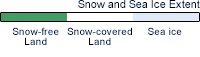
What do the colors mean?
The white areas on these maps show where Earth's lands were covered by snow for the time period indicated. The light blue areas show where Earth's oceans were covered by ice. Green areas show lands with no snow cover and black areas show oceans with no ice cover.
Get Data
1. Visit the NSIDC site
2. Make sure you create/ sign in to your Earthdata account
3. Download via HTTPS for the dataset you need
Notes
For this collection, snow cover data are only available for the Northern Hemisphere, and only in 7-day composite periods. NEO also offers another collection of daily global snow and sea maps for both hemispheres.
This dataset combines snow cover and sea ice extent at weekly intervals from October 23, 1978 through June 5, 2005, and snow cover alone from October 3, 1966, through October 23, 1978. (Sea ice data were not available prior to October 23, 1978.)
Related Websites
Special Sensor Microwave/Imager (SSM/I)
Advanced Very High Resolution Radiometer (AVHRR)
Northern Hemisphere EASE-Grid Weekly Snow Cover and Sea Ice Extent Version 3
Further Reading
Credits
Images by the National Snow and Ice Data Center (NSIDC) in Boulder, Colorado, using satellite passive microwave data from the Scanning Multichannel Microwave Radiometer (SMMR), the Special Sensor Microwave/Imager (SSM/I), and the Advanced Very High Resolution Radiometer (AVHRR).
Federal Geographic Data Committee Geospatial Metadata
View the FGDC Metatdata for Sea Ice and Snow Extent, Northern Hemisphere (1 week)