


![Average Land Surface Temperature [Day]](/images/datasets/132x66/MOD_LSTD_CLIM_M.jpg)
![Average Land Surface Temperature [Night]](/images/datasets/132x66/MOD_LSTN_CLIM_M.jpg)


![Land Surface Temperature Anomaly [Day]](/images/datasets/132x66/MOD_LSTAD_M.jpg)
![Land Surface Temperature Anomaly [Night]](/images/datasets/132x66/MOD_LSTAN_M.jpg)
![Land Surface Temperature [Day]](/images/datasets/132x66/MOD_LSTD_M.jpg)
![Land Surface Temperature [Night]](/images/datasets/132x66/MOD_LSTN_M.jpg)


NEO News
How to add NEO layers to your map using the NEO Web Mapping Service (WMS)
February 8th, 2021 by Andi Thomas
A Little Background Information on WMS
The Web Mapping Service (WMS) protocol has been around since 1999 and gives users the capability to access georeferenced maps via machine-to-machine contact. This means you can connect to a WMS server from a software of your choice that has WMS capabilities and load all or some of the datasets that are included on the WMS server you connect to.
There are a couple of required request types by a WMS server: GetMap and GetCapabilities. GetCapabilities provides information on what is available with a WMS service and GetMap provides the image map along with the image-specific metadata. NEO’s Capabilities Document is located on the WMS information page.
How to use the NEO WMS service
There are several ways to connect to NEO’s WMS server with different software. In fact, Wikipedia has a list of software with the WMS capability to explore. For this tutorial, we are going to use a free and open-source desktop geographic information system application called, QGIS. Assuming you have already installed QGIS on your machine, follow these simple steps to get started:
- Open a new QGIS project and go to Layer > Add Layer > Add WMS/ WMTS Layer…
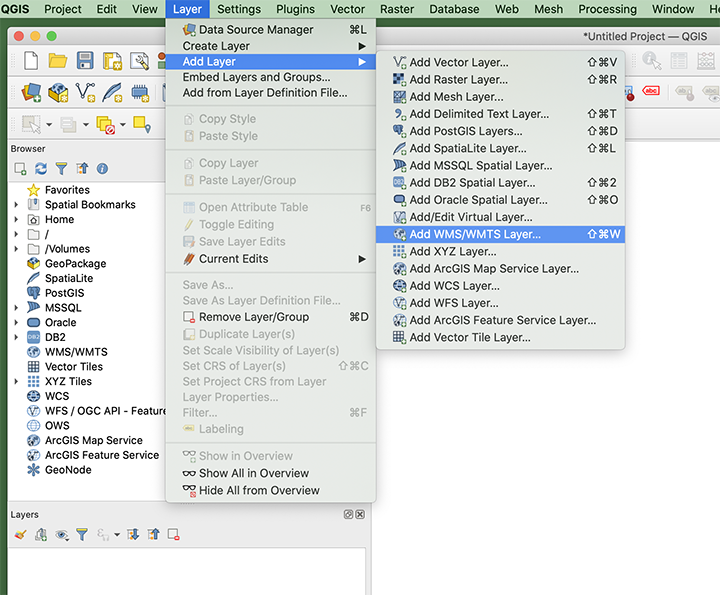
- The Data Source Manager window should have popped up. Click New and the Create a New WMS/ WMTS Connection window will pop up.
- Fill in Name and URL:
- For Name, I am going to call it, “NASA Earth Observations“.
- The NEO WMS URL is: https://neo.gsfc.nasa.gov/wms/wms
- Click OK and you will see the NEO datasets populate in the Layers box.
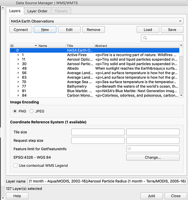
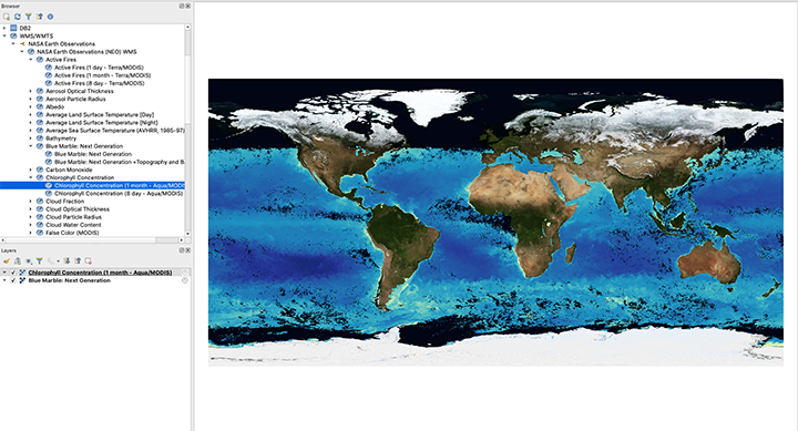
- You can Select the datasets you want to add to the map from here or, I prefer to close this window and add data to the map from the Browser window.
- From the Browser window, double-click a few of the datasets you would like to add to your map. I am going to add the Blue Marble basemap and the 1 month Chlorophyll Concentration Aqua/ MODIS dataset.
This is just a start to using the WMS service. There are plenty of other ways to use WMS capabilities as long as you have the URL (https://neo.gsfc.nasa.gov/wms/wms) and you know what datasets you want to use from the WMS service.
We would love to hear how you are using our WMS service. Please let us know in the comments below.
Comments Off on How to add NEO layers to your map using the NEO Web Mapping Service (WMS)
- Browse by Topic
- Analysis
- NEO in the Media
- New Datasets
- Services
- Uncategorized
- Browse by Date
- June 2026
- July 2025
- August 2024
- May 2023
- April 2021
- February 2021
- December 2020
- November 2020
- October 2020
- September 2020
- June 2019
- March 2019
- April 2015
- April 2014
- December 2013
- November 2013
- August 2013
- March 2013
- June 2012
- June 2011
- April 2011
- November 2010
- August 2010
- February 2009
- May 2008
- April 2007