


![Average Land Surface Temperature [Day]](/images/datasets/132x66/MOD_LSTD_CLIM_M.jpg)
![Average Land Surface Temperature [Night]](/images/datasets/132x66/MOD_LSTN_CLIM_M.jpg)


![Land Surface Temperature Anomaly [Day]](/images/datasets/132x66/MOD_LSTAD_M.jpg)
![Land Surface Temperature Anomaly [Night]](/images/datasets/132x66/MOD_LSTAN_M.jpg)
![Land Surface Temperature [Day]](/images/datasets/132x66/MOD_LSTD_M.jpg)
![Land Surface Temperature [Night]](/images/datasets/132x66/MOD_LSTN_M.jpg)


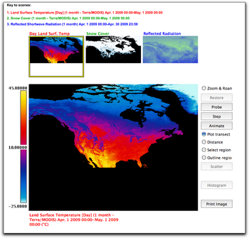
In this chapter from the Earth Exploration Toolbook, you can investigate satellite images displaying land surface temperature, snow cover, and reflected shortwave radiation data from NEO.
Download, explore, and animate these images using ImageJ, a public domain image analysis program from the National Institutes of Health (NIH). Then use the web-based analysis tools built into NEO to observe, graph, and analyze the relationship between the three variables.
Tags: how-to
Leave a Reply