


![Average Land Surface Temperature [Day]](/images/datasets/132x66/MOD_LSTD_CLIM_M.jpg)
![Average Land Surface Temperature [Night]](/images/datasets/132x66/MOD_LSTN_CLIM_M.jpg)


![Land Surface Temperature Anomaly [Day]](/images/datasets/132x66/MOD_LSTAD_M.jpg)
![Land Surface Temperature Anomaly [Night]](/images/datasets/132x66/MOD_LSTAN_M.jpg)
![Land Surface Temperature [Day]](/images/datasets/132x66/MOD_LSTD_M.jpg)
![Land Surface Temperature [Night]](/images/datasets/132x66/MOD_LSTN_M.jpg)


Land Surface Temperature [Day] (1 day - Terra/MODIS)
Dataset you are currently viewing: March 12, 2025
Select Year
About this dataset
This map shows the temperature of Earth's lands during the daytime. Temperature is a measure of how warm or cold an object is. During the day, the Sun's rays warm Earth's lands. Some of this warmth rises into the air where gases catch and hold the warmth near the surface. These gases (called greenhouse gases) also help to warm Earth's land surface. We can use a thermometer to measure the temperature of any single place. Likewise, scientists can measure the temperature of the whole world from space using instruments carried on satellites. Scientists want to know the land's temperature for many important reasons. For example, in places where it is too hot or too cold food crops may die. Temperature also influences weather and climate patterns. So, mapping the temperature of Earth's lands helps scientists to better understand our world.
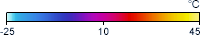
What do the colors mean?
The colors on these maps represent temperature patterns of the top millimeter (or “skin”) of the land surface — including bare land, snow or ice cover, urban areas, and cropland or forest canopy — as observed by MODIS in clear-sky conditions for the time period indicated. Yellow shows the warmest temperatures (up to 45°C) and light blue shows the coldest temperatures (down to -25°C). Black means “no data.”
Get Data
1. Visit LP DAAC for daily/ 8 day/ monthly data:
MOD11C1 (daily),
MOD11C2 (8-day),
MOD11C3 (monthly)
2. Select Access Data and choose one of the tools available to download the data you need
Related Websites
Further Reading
Terra Data Confirm Warm Dry US Winter
Hottest Spot
Baked Alaska
Heat Broils the American Southwest
Alaska Hit with a Hot March
Heat and Fire Scorches Siberia
ATBD (Algorithm Theoretical Basis Document)
Credits
Images by the NASA Earth Observations (NEO) team using data courtesy of the Land Processes Distributed Active Archive Center (LPDAAC) and the MODIS Land Science Team.
Federal Geographic Data Committee Geospatial Metadata
View the FGDC Metatdata for Land Surface Temperature [Day] (1 day - Terra/MODIS)
Quick Tip
Want all the images from a single dataset in either color or grayscale? Try downloading them in bulk.